
Seas are rising around East Boston. Will the community survive?
By Andrew Brinker
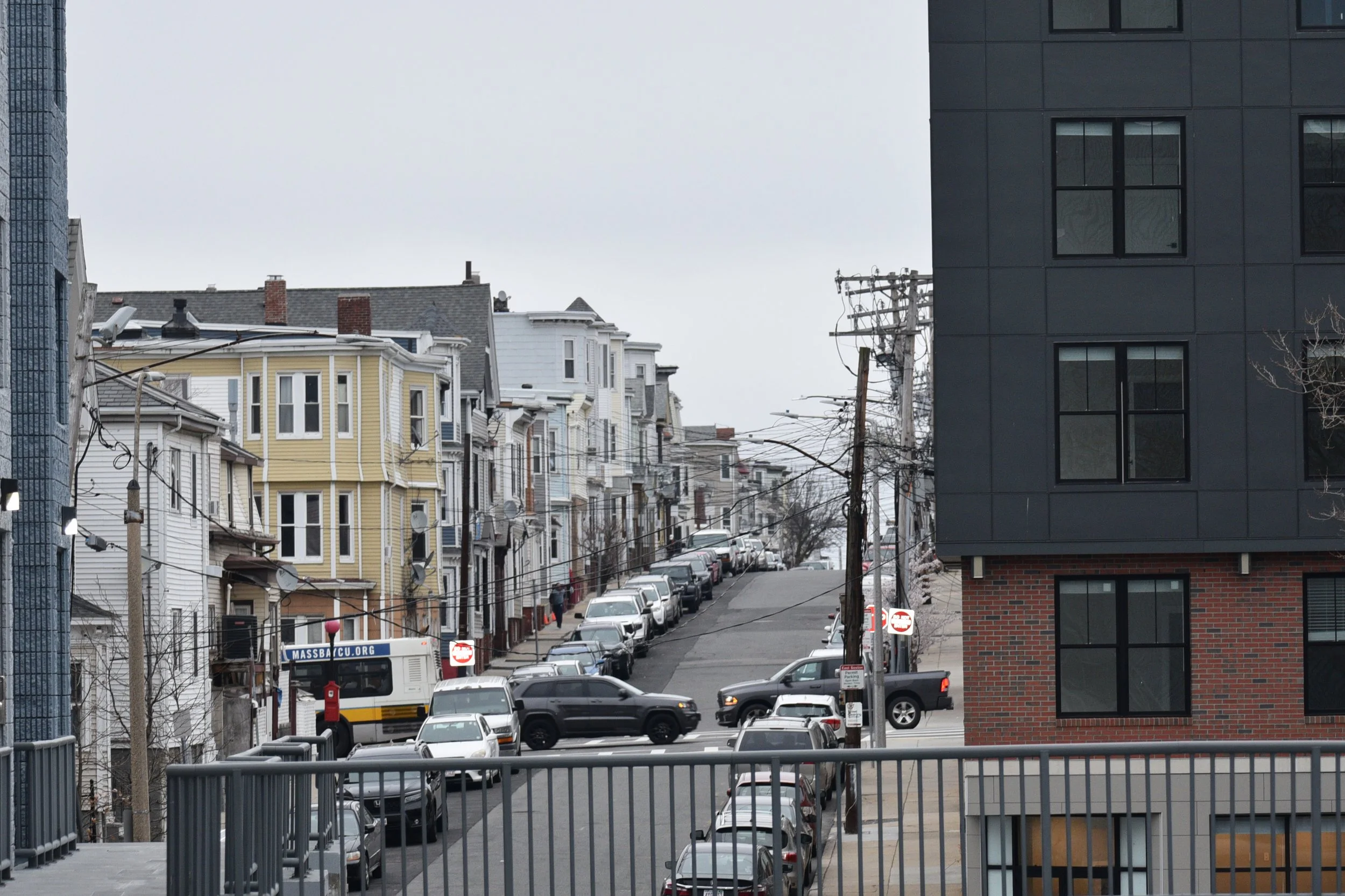
EAST BOSTON — On a particularly windy day earlier this month, as dark clouds plump with rain rolled towards the city, Iris Cedeno glanced nervously out the window at the water below.
For some 13 years, Cedeno, 35, has watched the churn of Chelsea Creek from her sixth-floor apartment at East Boston’s Shore Plaza East, an income-restricted housing development where she lives with her mother and three young boys.
The water had always been a welcoming presence, its gentle ripples perfectly framing the view of Boston and the Tobin Bridge. Cedeno’s boys find great joy in watching cargo ships float towards the harbor.
But it is this natural water — Boston’s intricate system of rivers and harbors, all fed by the swelling Atlantic Ocean — that threaten the city as well. Soon, even now, it threatens to spill over onto our shores during storms, flooding aging homes and vital infrastructure. Cedeno knows it. She witnessed her neighborhood’s streets inundated in the nor’easter of 2018.
“In a way, it feels like a ticking time bomb,” she said, peering at the river from the balcony outside of her apartment. “I’ve seen it flood here probably four or five times now. There are days when I really wonder, ‘how long until people can’t live here?’”
To be sure, the answer is complicated, if not impossible to answer conclusively. What is clear, though, is that there will be an increasing number of people like Cedeno over the coming decades — residents and property owners — who will bear witness to the inevitable rise of the sea and wonder how much longer their homes can hold on.
And while the threat sea level rise poses to property is a question that is yet to enter the mainstream discourse around climate change, it is a challenge that is uniquely pressing for a city like Boston, surrounded by water and built around one-sixth on landfill.
Look to East Boston, a diverse community struggling with its identity that has seen the warning signs and will soon find itself on the front lines. There, an alarming percentage of housing units fall in the path of flood projections over the next 50 years. Can those properties be saved? Or will the flooding become too frequent to salvage them? Will a housing market beleaguered by frequent flooding still have room for the longtime residents who have made this place their own?
For Cedeno, the question becomes: “Will my kids be able to live here when they’re older if they wanted to?”

Iris Cedeno, 35, pictured outside of her apartment at Shore Plaza East, an income-restricted housing complex on the shore of Chelsea Creek in East Boston.
Rising Seas
For decades, scientists have warned that our seas are rising, and fast. Centuries of worldwide industrialization, built largely on fossil fuels, has left us reliant on an energy source that leaches carbon dioxide and other greenhouse gasses into the atmosphere in huge quantities. Those gasses eat away at the ozone layer, a vital shield that limits the amount of solar radiation absorbed and refracted by the Earth.
With a depleted ozone layer, some ultraviolet rays are reaching Earth, warming air and water temperatures, causing massive amounts of ice to melt, and slowly swelling our seas.
To date, the effects of sea level rise have yet to inflict damage on a large scale, though, in some extreme cases, communities have already been pushed to the brink. In 2016, the federal government dolled out millions in grant dollars to Isle de Jean Charles, a thin strip of an island connected to coastal Louisiana by bridge. The money was earmarked, in effect, to move the community inland because its roads were quickly becoming impassable.
In Boston, sea level rise has been far less pronounced, but not unseen. Three or four times a year, king tides send waves spilling over docks and streets in the Seaport.
And of course, there was the nor’easter in January 2018, widely considered a slap-in-the-face wake up call for the city on climate change. The storm flooded streets in the financial district and East Boston with an icy sludge and left portions of the Blue Line temporarily inoperable.
That, experts said, is only a taste of what is to come.
Waters around Boston have risen about 8 inches over the past 70 years, a little more than an inch every decade, according to data from the National Oceanic and Atmospheric Administration. But seas are rising much faster now. By the 2030s, the sea level around Boston is expected to climb 9 inches above levels recorded in 2000, even if there is a major reduction in carbon emissions, the city’s environment department projects.
On their own, those predictions are alarming. Couple them with the expectation that severe coastal storms will become stronger and more frequent, the danger presented to Boston becomes existential, said Michael Martello, a doctoral candidate in the Massachusetts Institute of Technology’s Urban Mobility lab who has published research on the implications of sea level rise for the city’s infrastructure.
“To be frank, this is a tough situation for Boston to negotiate out of,” said Martello. “Even under the city’s modest projections, we’re looking at regular coastal inundation for large portions of the city. And that’s flooding that, of course, is going to have implications for our infrastructure.”

Projected flooding during a 10% annual storm, at 36 inches of SLR. Source: Climate Ready Boston (Map made with Tableau. Link.)
In East Boston, the projections are particularly bleak. During a coastal storm that has a roughly 10 percent chance of occurring each year, at 36 inches of sea level rise over levels recorded in 2000, large portions of Maverick Square, Jeffries Point, and Orient Heights — all residential neighborhoods — would be inundated. Boston is expected to hit 36 inches of sea level rise by 2070, according to the city’s projections. In that scenario, the only neighborhood that would not see major flooding is Eagle Hill, thanks to its elevation relative to sea level.
What makes the rest of East Boston so uniquely vulnerable? To put it simply, it's quite flat. About one sixth of Boston was constructed on landfill. Much of that fill helped build out the stretch of land that is today East Boston. In hindsight, the neighborhood was built far too close to sea level, said Martello.
“You can’t really blame [the people who constructed the city],” he said. “It’s hard to think that far ahead, especially since the science of sea level rise wasn’t really established. So they were dumping dirt to make flat, inhabitable land. But if our ancestors had just added, say, an extra five feet of dirt, we wouldn’t have any of these problems.”
Some residents in areas nearest the water have already seen a glimpse of the future. Cedeno, for example, watched Chelsea Creek spill over a rocky seawall and into the parking lot of her sprawling housing complex. The lot is on ground level, directly beneath the complex’s six floors of apartment units, the lowest of which are elevated some 15 feet off the ground by beams.
“I’ll never forget it,” said Cedeno. “I walked down to my car and the water was like four inches up my tire.”
A street arches up towards Eagle Hill.
Vulnerable infrastructure
For decades, East Boston was considered, at least by white, wealthy residents, one of the city’s least desirable neighborhoods because of its geographic disconnect from downtown. As a result, rent prices stayed low, and the neighborhood flourished as a haven for immigrants, most of them Latino.
But the tables have turned in recent years as property value within city limits has shot up. In East Boston, developers saw a wealth of undeveloped land, old homes, and opportunity. What once were seen as disadvantages became the neighborhood’s selling point. For most people, the commute via car to downtown only ranges from 10-30 minutes, no longer than a drive from Brighton or Jamaica Plain. And the Blue Line brought value to the neighborhood as well, said Frances Gomez, an organizer with the advocacy group City Life/Vida Urbana.
The result has been more than a decade of gentrification in East Boston. Developers have snatched up empty parcels of land and purchased old homes en mass to build higher end apartment buildings, driving up the price of rent and forcing longtime residents, some of whom are undocumented, out. In has come an influx of middle and upper class white people, seeking out the space and comparatively lower rent prices the neighborhood offers.
“We are being pushed out by the thousands,” said Gomez. “People are living with nine roommates in a two-bedroom apartment to avoid leaving the neighborhood and losing their job. Latino people, immigrants, we have a history here and we’re losing it.”
The median home value in East Boston has skyrocketed over the past decade, but the price increase has intensified in particular over the last year. From 2020 to 2021, the median price for a home in East Boston rose roughly 11 percent, according to Zillow. As a result, rents have shot up, too.
“If the city does not step in to cap rents or development, it will be too late,” said Frances Amador, another City Life/Vida Urbana organizer.

Median rent price in Boston by neighborhood (2020). Source: ACS 5-year survey, US Census Bureau. Made with Tableau. Link.
Sea level rise, which will send flood waters encroaching on valuable waterfront property, only serves to push prices higher, experts say.
The question is when and by how much.
The most severe impacts of sea level rise — ultimately, owners abandoning properties that are the subject of frequent flooding or in extreme cases properties being swept into the ocean — are far off, perhaps a century in the future. But the market will respond to the impending threat of sea level rise far sooner, said Philip Mulder, a microeconomist and doctoral candidate at the University of Pennsylvania’s Wharton School of Finance, who has studied the effects of sea level rise on the housing market.
“Sea level rise per se, isn't going to destroy your home, at least right now,” said Mulder. “But what you might have is increased flood insurance premiums, higher risk of a hurricane. The phenomenon of sea level rise is distinct in that it has the ability to influence the market when the worst case scenarios are at the very least 30 years or so off.”
At the core of the problem is infrastructure. Many homes in flood prone areas are not well-equipped to handle the flow of water they will eventually see.
Salt water, Mulder explained, is extremely damaging to carpet and wood. Oftentimes, key pieces of infrastructure like generators, water systems, and air conditioning components, are kept in the basement. In a flood, they’d be destroyed. And the movement of water around a home can cause erosion, which can have implications for a property’s structural integrity.
Compounding the issue, said John Walkey, the director of waterfront and climate justice initiatives at the Chelsea-based advocacy group GreenRoots, are big developers, who are still building homes and apartment buildings without climate resiliency in mind.
There is no published research on the effects of sea level rise on Boston’s housing market, but scholarly work on other coastal communities may offer a forewarning.
Look to coastal Florida, where a study conducted by Mulder found that, between 2013 and 2018, home sales volume in areas vulnerable to coastal flooding fell by somewhere between 16 and 20 percent.
Until 2018 the value of the homes remained steady, but subsequent preliminary research found that, between 2018 and 2020, relative home prices and mortgage values in that area fell about 5 percent. As Mulder explains it, that means home owners began to realize that, because of their property’s vulnerability to coastal flooding, buyers were less likely to purchase at what would otherwise be market price.

Housing units in Boston per capita (2020). Source: ACS 5-year survey, US Census Bureau. Made with Tableau. Link.
Flood Factor, a website that analyzes urban flood risks, found that there are 1,338 properties in East Boston, or 20 percent of all properties in the neighborhood, that have a greater than 26 percent chance of being severely affected by flooding over the next 30 years.
If sea level rise continues at its current pace or quickens, that number is likely to rise. Another study found that affordable housing in Massachusetts is among the most vulnerable in the country to sea level rise.
That unique vulnerability has a number of untested implications for the housing market, perhaps in East Boston.
Perhaps, Mulder theorized, properties in the path of flooding will decrease in value over time, but people, presumably people with less money than traditional waterfront property owners or renters, will continue to buy those properties.
In that scenario, the result may be what some have labeled “climate gentrification.” In theory, the value of properties inland would increase over time, and lower income communities would be forced directly into the path of flooding.
Regardless of exact outcome, there is no disputing that the housing market will be impacted by rising seas. Walkey, of GreenRoots, argued that lower income communities like the longtime residents of East Boston who are predominantly Latino, will be bear the brunt of the burden.
“Certain neighborhoods are going to get screwed,” said Walkey. “It's always the same people who are bailed out, and the same people who do not get bailed out. The small triple decker in East Boston with a pump in the basement going on at every high tide, they're going to have to just bite it, take a loss on the building and sell it for pennies. But these huge buildings that are built by big developers on the waterfront without thinking about climate change for a second, they’ll get the handouts.”

Housing units per capita (2020), overlaid with flooding predicted during a 10% annual storm in 2070. Source: ACS 5-year survey, US Census Bureau/Climate Ready Boston. Made with Tableau. Link.
A resilience plan, but will it be enough?
The next 50 years will prove a trying test for Boston. Under its Climate Ready Boston initiative, lauded as one of the most ambitious in the US, the city has plans for what will amount to billions of dollars in infrastructure efforts that officials hope will ward off the rising sea.
Operating under the assumption that the oceans will have risen 36 inches above levels recorded in 2000 by 2070, they’ll build berms, elevate parks, and explore the possibility of sea walls.
“We've got a history of big civic infrastructure projects that have been transformative to this city,” said Chris Busch, the assistant deputy director for climate and environmental planning at the Boston Planning and Development Agency. “This is just another step in that evolution. The intent and hope is that 50 years from now we're going to have a waterfront that looks and functions differently, but that is more accessible and vibrant and maintains and enhances the habitat.”
But even Busch acknowledges that the plan will not hold off flooding in its entirety. The BPDA is advising property owners in the path of sea level rise to plan for regular flooding as a reality, not a possibility. It's telling those owners to begin thinking about pulling essential infrastructure out of basements and to invest in other resiliency efforts.
As of now, though, there’s no federal funding to support these efforts, leaving the burden of cost on property owners. As a result, very few have taken any action, Busch said.
Some, including Walkey, see a fundamental flaw in the city’s planning. All efforts hinge on sea level rise predictions for 2070. What about after that?
Walkey predicts a reality that very few in Boston want to imagine: retreat, at least for some neighborhoods.
“We’re eventually going to figure out that in our future, the waterfront in some of these neighborhoods like East Boston is just not the place to have properties,” he said. “We’ll have to determine how and when to cut bait on these properties. That's a horrible question for a municipality, because the lifeblood of a municipality is property tax, but it's something we’ll have to address.”
It's another possibility that will disproportionately impact the city’s most vulnerable, like those in East Boston.
Busch rejected the premise of retreating from certain neighborhoods as far-fetched and said the city is working to include equity at every turn of its sea level rise planning.
Those questions are beyond Cedeno, who figures she won’t be alive to see such extreme flooding. She worries for her kids, though. On clear days, she spends her evenings on her balcony, cigarette in hand, watching the waters of Chelsea Creek lap closer to shore than they did 13 years ago.
“I’ve spent all my life here,” she said. “I want my kids to have that too.”
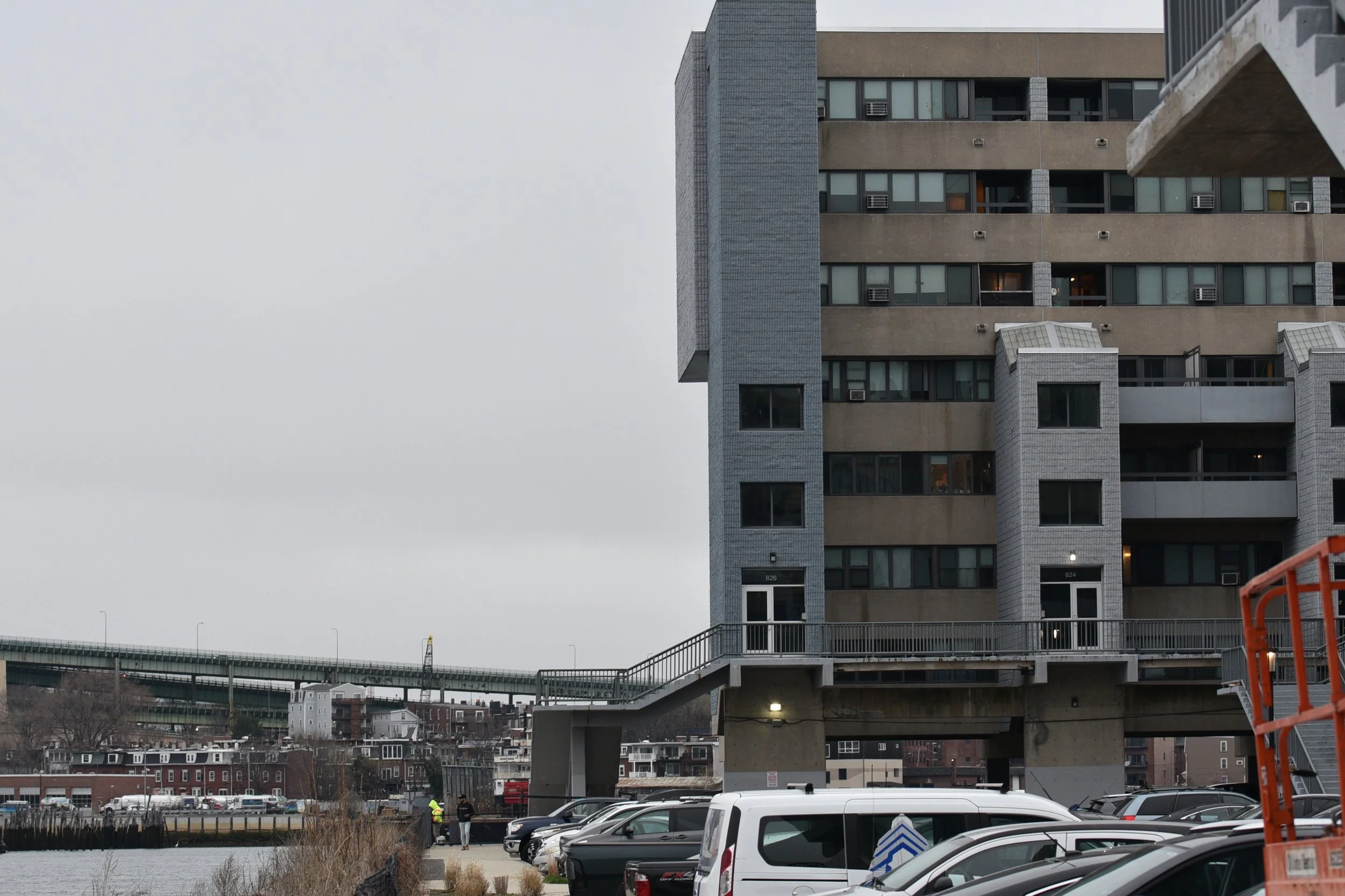
The Shore Plaza East apartment complex.